

Idaho Board Charges Surveyor Chad Erickson


 Share
This Article
Share
This Article
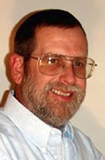
Surveyor Chad EricksonBy Edward Snook
Investigative ReporterIdaho County, ID – In previous editions of the US~Observer we published articles covering an alleged land theft in northern Idaho. In late 2009, Sydney “Butch” Walker and his wife Dorothy were forced to file a civil lawsuit against neighbors, Bessie Harmon, Etta Harmon, Ellen Hoiland, Dean Hoiland, and Elvin Harmon (Harmon/Hoilands) who were allegedly encroaching on Walkers’ land.
According to the Walkers, “We were attempting to protect our property boundaries according to property lines that were detailed to us when we were purchasing our acreage in 1968…” The Walkers had no idea when they purchased much of Section 24 that they were buying into a surveying nightmare.
When the Harmon/Hoilands (adjacent neighbors to the south in Section 25) began building a structure on property the Walkers knew was part of their Section 24 land, they hired an attorney out of Boise, Idaho named Dennis Charney and a surveyor out of Idaho County named Chad Erickson to protect their boundaries.
In 2009, Charney filed a lawsuit and Erickson began bilking the Walkers, out of what would eventually become $37, 856.00, for his “bogus” surveying (even Erickson used the term “bogus” to describe his own monument). When the Walkers finally discovered that Erickson was coming up with “substantially incorrect surveys and reports”, they fired him and hired surveyor Steve Wellington out of Meridian, Idaho.

Surveyor
Hunter Edwards
Surveyor
Hunter EdwardsSurveyor Hunter Edwards was hired by the Harmon/Hoilands as an expert to render opinions on the south line of Section 24, not the NW corner. Yet, Hunter Edwards, in an attempt to allegedly expand the scope of surveys for his future, deliberately moved, or at least attempted to move the NW corner of Section 24 on February 7, 2014. It was Hunter Edward’s 2001 survey that the Harmon/Hoilands used against the Walkers to lay claim to the land in Section 24.
When Hunter Edwards attempted to go onto Walker property to re-set the NW corner (a job he was not hired to do nor was he permitted by law to do without the permission of the Walkers and their adjacent landowners) the Walkers refused to allow him access. Idaho has a “no-right-of-entry” law, which means Hunter Edwards was trespassing if he stepped onto Walker property without their permission.
Road to Exposure
Walkers, after discovering nearly a hundred years of incompetent, unethical surveying in Idaho County, Idaho, eventually found that they would have to expose the whole sequence of events, including the 1977 allegedly fraudulent survey by local surveyor Carl Edwards, where he re-located the SW and SE corners of Section 24, just outside of Grangeville. This was nine years after the Walkers purchase of their property, based on original corners, set permanently by government surveyors in the late 1800s under U.S. Homestead laws (by official Government Land Office (GLO) surveyors).
In 1977, the Walkers had no idea that Edwards had done this. It is important to note, Carl Edwards (father of Hunter Edwards - another allegedly fraudulent Idaho County surveyor) was required by law to officially record newly placed corners, even “fraudulent corners,” within 90 days in order to give members of the public, such as the Walkers, an opportunity to raise objections. Carl Edwards failed for 19 years to do this, choosing instead to wait until 1996 to record, and then he only recorded some of his 1977 corners – at this point, the reader must be wondering why. Well, according to one expert surveyor we spoke with, “Edward’s new SW corner was so far out of whack that it is just fraudulent;” and according to another expert, “failing to record made it virtually impossible to either identify or correct the fraud, giving it the false appearance of a condition of ‘repose,’ making it appear that the incorrect corners had been accepted by acquiescence.”
In 2013, Walkers’ attorney Charney filed a Motion seeking court approval of an arrangement that he had made, without authority. When the Walkers read the Motion, seeing the new property lines that Charney was asking the court to approve, they knew “he was giving away their land, in an attempt to settle the long standing case” against their interest. Unable to communicate with Charney who had conveniently made himself unavailable and realizing they were in jeopardy, the Walkers contacted the US~Observer to investigate and look into this devastating situation.
The US~Observer agreed to investigate the Walker case, Charney was fired and over the past two years we have conducted an in-depth investigation only to find that over 100 years of incompetent or dishonest surveying allowed adjacent landowners to falsely claim ownership of property from their neighbors.
It now appears that recent “mistakes” in surveying may have been driven by a desire to create more surveying business for Idaho County surveyors in the future and we will report on that in more depth in our next article; but the lesson here may be that because of the “ripple effect” more property may be stolen in Idaho County because of the “fraudulent” surveys near Grangeville by Carl and Hunter Edwards
The Walkers are working to contain the situation, keeping the problem local by trying to resolve it locally. But, when surveyors take “license” to move permanently established boundaries to suit the latest land-grab scheme, as opposed to sticking with survey monuments that were established by the original 1800’s GLO surveys, litigation is promoted, with neighbors being polarized. This is the genesis of the entire problem. If property lines in Sections 23, 24, 25 and 26 can be moved at the whim of a surveyor, where does it all end? Does the entire state need to be re-surveyed until we reach the initial point at the Boise Meridian? If this absurd approach is taken, then every landowning person in the state may need to be added to the Walker’s lawsuit..
Our surveying expert verified in short order that Charney’s Motion had stated completely wrong property descriptions and we were shocked to find that Charney had charged the Walkers an enormous amount of money for his so-called “legal work,” that was actually “aimed at throwing them under the bus.” We are currently attempting to obtain the exact amount Charney charged and will report on this soon.
Attorney Wesley W. Hoyt of Clearwater, Idaho was hired to help correct the mess that Charney and Erickson had created and he was able to retract the Motion that Charney had filed.
At this juncture, surveyor Pete Ketcham was hired by the Walkers to begin surveying the south line of section 24, because the Walkers knew the survey that Wellington had filed two years prior was incorrect. After much hard work, studying historical facts, Ketcham discovered the original, historic SW corner of section 24, which Wellington had overlooked. When found, Wellington recognized that the original stone found by Ketcham was indeed the actual GLO SW corner of Section 24 and he agreed to revise his survey recognizing this monument.
Hoyt subsequently appeared on Charney’s original lawsuit against the Grangeville Highway District and it was dismissed without prejudice because the suit did not name all adjoining landowners who would be affected by the Court’s ultimate boundary decision.
Surprisingly, surveyor Steve Wellington did a sudden “180” after having stated to the Walkers’ in the presence of third parties that he would place the southern boundary of the Walkers’ land at its original GLO location, which was much further south than Chad Erickson’s line (and south of Wellington’s previous line); then he changed his mind without informing his client. He had previously stated that he was accepting the original stone found by Pete Ketcham at the SW corner and the U.S. Government’s SE Angle Point, which was the basis for Ketcham’s south line. However, after he had allegedly conversed with Chad Erickson, he decided to use a line very close to Erickson’s line and recorded his Revised Record of Survey on October 15, 2015. This action really convoluted this case in that Erickson’s south line deprives the Walkers of over 35 acres of property that was originally part of Section 24, according to the expert surveyors we have spoken with. This is a “wealth transfer by
surveyor” which is not permitted by any law that we know of.
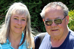
Dorothy and Butch WalkerWhat Wellington did was charge the Walkers $30,059.36 for his work, while agreeing that the south line should be placed well below the contrived and calculated positions postulated by Erickson and Carl Edwards, which placement would have set the south line in its original GLO position and helped resolve the matter. Then by waiting over two years, he charged up a big bill, then surreptitiously changed his survey that the Walkers were relying upon to prove their lawsuit. I don’t know what the Board of Surveyors call this, but at the very least it is blatantly unethical - it is what I call stealing!
At this juncture, and tired of being cheated over and over by “professionals”, the Walkers hired two additional surveyors, Jeffrey Lucas (nationally recognized as an expert’s-expert) out of Alabama and “federal surveyor” Matt Mayberry of Hayden, Idaho. Mayberry recently filed a Record of Survey on the west line of Walker’s section 24. Both of these expert surveyors agree that Pete Ketcham’s south line and SW corner reflect the original GLO locations. The Walkers needed additional surveyors to survey their west line and to validate that their south line was correct.

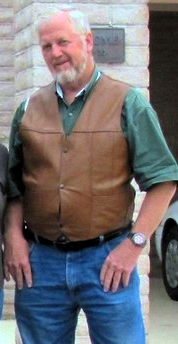
Attorney Wes HoytHoyt filed an amended lawsuit on July 16, 2015, naming adjoining property owners and he also named surveyor Hunter Edwards as a defendant, claiming slander of title for attempting to move the NW corner of Sec. 24, which had been accepted by all surveyors since 1902 (even Hunter Edward’s father did not question the historically recognized 1902 location of the NW corner).
Judge John Stegner would not allow Hoyt’s suit for slander of title because it added Edwards who was not an adjoining landowner, so Hoyt is now in the process of refiling the property line suit and will be filing a separate lawsuit against Hunter Edwards.
The evidence is mounting that original GLO monuments and “fraudulent stones” have been placed in the field by both Hunter Edwards and his father, Carl Edwards over the years; making them the chief suspects in a case for property theft.
On December 14, 2015 Judge Stegner extended the time for Hoyt to file the amended complaint with permission until February 8, 2016, so that all the adjoiners could be named and any other property owners whose boundary would truly be affected by the lawsuit.
The Idaho Board
Due to complaints reportedly received by the Idaho Board of Licensure of Professional Engineers and Professional Land Surveyors (Board) against Hunter Edwards, Chad Erickson and others, combined with the length of time (five-plus years) this dispute has been going on, the Board decided to move ahead with their obligations under the law.
The Board filed charges against Chad Erickson of Idaho County on October 28, 2015. Allegations contained in the complaint against Erickson include “fraud, misconduct and negligence in his survey report”. He was also accused by a client of “criminal and fraudulent misconduct”.
The Complainant in the case against Respondent Chad Erickson is the Board’s Executive Director Keith Simila. Simila's
“Prayer for Relief” states, “In the case of default only, Complainant recommends that the Board take the following specific disciplinary action regarding the license issued and held by Respondent: the assessment of a $5,000.00 fine, and a 3-year suspension of Respondent’s license.”
Executive Director Simila and the Board should be commended for beginning to hold this out of control surveyor accountable.
Steve Wellington surely must have started getting heart burn the moment he heard of the charges, as he had “jumped into bed” with Erickson and filed his amended Record of Survey, virtually a mirror image of the incorrect Erickson survey, just about one week prior to Erickson being charged.
Carl Edwards has retired from the practice of surveying. As for the Board’s charges against Hunter Edwards, we haven’t obtained any documents yet. We will report more on this issue when we obtain the actual alleged charges.
None of these surveyors (Carl and Hunter Edwards, Chad Erickson and Steve Wellington) have respected the regular pattern of surveying achieved by the original GLO survey of the 1800s and it is obvious to this writer that the motivation was to give an unfair advantage to adjacent property owners who gained significant amounts of property from these surveyor’s calculated boundary lines, which do not respect the original monument positions established by the GLO.
It is very clear that the Board has their work cut out for them. They have a real “Mess” on their hands because incompetent and/or unethical surveyors created it for them.
As for the Walkers, in September, 2015 Sydney (Butch) Walker passed away and now it is up to Dorothy to handle this literal nightmare all by herself. According to one highly qualified witness, “What the false surveys have done is allow some property owners, with a desire to steal from their neighbor(s), the opportunity to claim that moving fences and property boundary markers onto Walker land is justified”. According to Attorney Hoyt, “Bad surveying is an open door to theft of property.”
Dorothy Walker told me during a recent conversation, “I have to finish this, I am not going to allow people to take our property and I will certainly not allow surveyors to take advantage of me. Butch would want me to hold these people accountable.”
Walker is currently seeking a civil attorney to file suit against Chad Erickson, his fellow surveyor Steve Wellington and others.
Rest assured, I have a very good idea who originally put Carl Edwards up to starting this whole mess back in the 1970’s and I will be exposing them in the near future. This family and their cohorts think they are untouchable; however, they will find out quite the opposite when they read the evidence I have been compiling over the past two years.
Editor’s Note: If you have information, of any nature, on those involved call 541-474-7885 or send an email to editor@usobserver.com. We are specifically seeking information on Grangeville surveyors Hunter Edwards, his father, Carl Edwards, Chad Erickson and Steve Wellington. Also, landowner Mike Frei and his brother Jerry who is a Commissioner for the Grangeville Highway District, which is involved in this case. Mike Frei’s property adjoins property owned by Dorothy Walker.
Subscribe to the US~Observer News Flash Alerts!
Subscribe
to the US~Observer |
Get
a subscription to US~Observer delivered
right to your mailbox via first-class mail!
Click Here for more information